
Introducing MapImager On-Line™
MapImager On-Line™ from Telemorphic, Inc. makes it fast, easy, and intuitive for an unlimited number of visitors to your organization's website to perform real-time comparisons of high resolution imagery and/or maps. Works great for intranet internal use as well. (Read more...)This page includes examples for the San Francisco / Bay Area, highlighting changes over the last 150 years.
| 75' vessel, wrecked on a building Before: June 23, 2004 After: Dec. 28, 2004 |
||
| San Francisco Before: 1946 Aerial Photo After: 2001 Aerial Photo |
 |
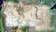
San Francisco Bay / Treasure Island Before: 1852 Nautical Chart After: ~1990 Topo Map |
| Monster (Candlestick) Park Before: 1946 Aerial Photo After: 2001 Aerial Photo |
||
Requirements:
Connection: 56K minimum, broadband recommended
Java: JRE 1.3.1 or later. (Should install automatically. If there are any problems, you can visit Sun's Java pages at https://www.java.com/en/download/ for an alternate automated installer.)
Data sources:
1852 Nautical Chart - David Rumsey collection
1946 Aerial Photo - USGS DOQQ
1990 Topo Map - USGS (date approximate)
2001 Aerial Photo - San Francisco Government
Usage Guidelines:
Images from MapImager On-Line and/or this website may be published electronically, in hardcopy or in broadcast as long as credit is conspicuously provided to "Telemorphic" and the appropriate data source(s).
For print, presentation and Web materials: Credit to Telemorphic and the appropriate data source(s) must appear next to or beneath the photo.
For broadcast: Credit to Telemorphic and the appropriate data source(s) must appear on-screen throughout the entire air-time.
Additionally, if the products are referenced verbally during the program, they must be verbally attributed to Telemorphic and the appropriate data source(s).
Any usage of MapImager On-Line™ or the images other than that specifically described above requires the permission of Telemorphic.
For a clickable image of the area, visit here.