
 Custom Solutions
Custom Maplicity™ solutions are also available for any internet map or image server technology and/or web service(s). Here are a couple examples. Contact us to discuss your requirements.
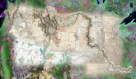
On-Line Agricultural Information System for Pixxures, Inc. and Resource21, LLC.
 Pixxures,
Inc., a leading provider of on-line access to satellite imagery
and high resolution aerial photography archives, required a high
performance, easy-to-use web enabled application to support interactive
imagery analysis and GIS functionality as part of an on-line enterprise
agricultural information system (AgSense™ by Resource21). Telemorphic's
revolutionary Maplicity technology provided a very lightweight
(260kb) application that integrated seamlessly with Pixxures'
WebPix™ image delivery system, thereby providing instant on-line
access to nationwide high resolution imagery for agricultural
dealers (seed providers, ag chemical providers, corporate producers,
crop consultants, crop insurance adjusters) enabling them to quickly
and easily find and/or order imagery for customers' fields, draw/edit
field boundaries and exclusion areas based on the detailed imagery,
calculate accurate measurements of the fields, download/upload
GIS format data, print/save custom maps and reports, and even
conduct analysis of the site specific conditions within fields
based on crop vigor, nitrogen stress, soil moisture, and estimated
yield maps.
Pixxures,
Inc., a leading provider of on-line access to satellite imagery
and high resolution aerial photography archives, required a high
performance, easy-to-use web enabled application to support interactive
imagery analysis and GIS functionality as part of an on-line enterprise
agricultural information system (AgSense™ by Resource21). Telemorphic's
revolutionary Maplicity technology provided a very lightweight
(260kb) application that integrated seamlessly with Pixxures'
WebPix™ image delivery system, thereby providing instant on-line
access to nationwide high resolution imagery for agricultural
dealers (seed providers, ag chemical providers, corporate producers,
crop consultants, crop insurance adjusters) enabling them to quickly
and easily find and/or order imagery for customers' fields, draw/edit
field boundaries and exclusion areas based on the detailed imagery,
calculate accurate measurements of the fields, download/upload
GIS format data, print/save custom maps and reports, and even
conduct analysis of the site specific conditions within fields
based on crop vigor, nitrogen stress, soil moisture, and estimated
yield maps.
RadNet: A Mobile Distributed Radiation Threat Monitoring Network for Lawrence Livermore National Laboratory (LLNL)
 The
threat of nuclear terrorism presents one of the most complex challenges
to federal, state, and local government agencies responsible for
Homeland Security. While the possibility of a "dirty bomb" is chilling,
imagine the "silent bomb" scenario: Lethal concentrations of illicit
radioactive material are placed in densely populated buildings or
mass transit locations without any explosion. Weeks later, hospitals
begin to report the effects of mass radiation poisoning, but by
then it is too late for thousands of people. Lawrence Livermore
National Laboratory prototyped RadNet to aid in countering this
threat. RadNet is a network of GPS enabled mobile devices (cell
phone + PDA) fitted with gamma radiation detectors. The devices
collect radiation readings and locations at fixed time intervals,
and establish wireless connections for transmitting the data to
a server based Internet Geographic Information System (GIS), which
then stores, manages, and analyzes the data to generate "hot spot"
maps depicting locations of increased radioactivity. The maps can
then be quickly delivered on-line to first responders. The GIS for
RadNet consists of Telemorphic's Maplicity integrated with MapServer,
PostGIS, PostgreSQL.
The
threat of nuclear terrorism presents one of the most complex challenges
to federal, state, and local government agencies responsible for
Homeland Security. While the possibility of a "dirty bomb" is chilling,
imagine the "silent bomb" scenario: Lethal concentrations of illicit
radioactive material are placed in densely populated buildings or
mass transit locations without any explosion. Weeks later, hospitals
begin to report the effects of mass radiation poisoning, but by
then it is too late for thousands of people. Lawrence Livermore
National Laboratory prototyped RadNet to aid in countering this
threat. RadNet is a network of GPS enabled mobile devices (cell
phone + PDA) fitted with gamma radiation detectors. The devices
collect radiation readings and locations at fixed time intervals,
and establish wireless connections for transmitting the data to
a server based Internet Geographic Information System (GIS), which
then stores, manages, and analyzes the data to generate "hot spot"
maps depicting locations of increased radioactivity. The maps can
then be quickly delivered on-line to first responders. The GIS for
RadNet consists of Telemorphic's Maplicity integrated with MapServer,
PostGIS, PostgreSQL.