
Services
Custom Application Development
We offer custom application development services related to the integration, distribution, visualization, and analysis of geospatial information. We also provide application development and integration services that leverage our award-winning technologies to deliver affordable, best-of-breed Geographic Information Systems (GIS) and image analysis/visualization solutions designed to meet any customer's specific business requirements. Our engineering team possesses expertise in a broad range of software, toolkits, programming languages, and operating systems in addition to ESRI's complete geospatial product suite for the desktop, server, and web services. In addition, we offer expert technical support as well as hands-on solutions oriented training for our complete Maplicity, MapImager, MultiViewer and TopoMAX product lines.
Remote Sensing and GIS Consulting
Telemorphic also offers a variety of consulting services related to design, development, integration, and deployment of applications involving geospatial technologies and content. We draw on our years of hands-on integration experience with remote sensing and GIS data and applications to insure our clients get the most value out of their investment in geospatial technologies.
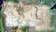
Example: David Rumsey Collection Internet GIS
 The
David Rumsey Collection Internet GIS is an example of our ability
to create complete turnkey solutions that incorporate unique web
mapping, GIS, and geospatial visualization functionality, combined
with our capabilities for aggregating and integrating a wide range
of geospatial content to meet a customer's requirements. Historical
maps, modern maps, aerial photos, satellite imagery, GIS vector
layers, and other spatial information are most relevant when two
or more layers can be viewed simultaneously in their geographic
context for interactive comparison as overlays, and/or side-by-side
in a linked viewer environment. This allows web browser-based
users to visualize and analyze differences in the maps or images,
which is particularly useful for investigating changes in the
landscape over time. We were able to quickly and cost-effectively
meet these requirements for web geospatial visualization thru
customization built upon our lightweight (350kb) off-the-shelf
product, Maplicity for ArcIMS. We also created the comprehensive
geospatial databases required for powering the Internet GIS, to
include precision georeferencing of over 250 historical maps,
aggregation of other geospatial content (modern maps, aerial photos,
satellite imagery, and GIS vector datasets), and integration of
this geospatial content to create ten (10) Internet GIS sites
representing major metro areas in the U.S. and Japan. This solution
has received numerous awards and recognition, and is widely recognized
as one of the most compelling mapping and GIS applications on
the Internet. [Live
demo]
The
David Rumsey Collection Internet GIS is an example of our ability
to create complete turnkey solutions that incorporate unique web
mapping, GIS, and geospatial visualization functionality, combined
with our capabilities for aggregating and integrating a wide range
of geospatial content to meet a customer's requirements. Historical
maps, modern maps, aerial photos, satellite imagery, GIS vector
layers, and other spatial information are most relevant when two
or more layers can be viewed simultaneously in their geographic
context for interactive comparison as overlays, and/or side-by-side
in a linked viewer environment. This allows web browser-based
users to visualize and analyze differences in the maps or images,
which is particularly useful for investigating changes in the
landscape over time. We were able to quickly and cost-effectively
meet these requirements for web geospatial visualization thru
customization built upon our lightweight (350kb) off-the-shelf
product, Maplicity for ArcIMS. We also created the comprehensive
geospatial databases required for powering the Internet GIS, to
include precision georeferencing of over 250 historical maps,
aggregation of other geospatial content (modern maps, aerial photos,
satellite imagery, and GIS vector datasets), and integration of
this geospatial content to create ten (10) Internet GIS sites
representing major metro areas in the U.S. and Japan. This solution
has received numerous awards and recognition, and is widely recognized
as one of the most compelling mapping and GIS applications on
the Internet. [Live
demo]
 |
 |